Geolocate

Smithfield topographic map

Click on the map to display elevation.

About this map

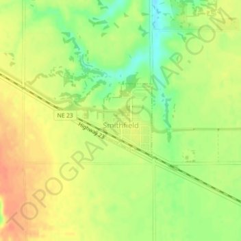
Name: Smithfield topographic map, elevation, terrain.

Location: Smithfield, Gosper County, Nebraska, United States (40.56889 -99.74490 40.57714 -99.73776)

Average elevation: 2,549 ft

Minimum elevation: 2,464 ft

Maximum elevation: 2,608 ft

Gosper County trails, hiking, mountain biking, running and outdoor activities

Other topographic maps

Click on a map to view its topography, its elevation and its terrain.

Johnson Lake

United States > Nebraska > Gosper County

Average elevation: 2,618 ft

Gear up for your next adventure:

🎁Geography Themed Gifts - Unique gift ideas for map lovers and geography enthusiasts
🔋Rechargeable Batteries - Power up your outdoor devices
🎒Hydration Pack - Hands‑free water reservoir for long hikes
🦶Hiking Gaiters - Keep debris and water out of your boots
🪓Survival Multi‑Tool - Versatile tool for camp and trail tasks

As an Amazon Associate, this site earns from qualifying purchases at no extra cost to you.