
Thank you for supporting this site ❤️
Make a donation
Make a donation
Gear up for your next adventure:
As an Amazon Associate, this site earns from qualifying purchases at no extra cost to you.
Viguí topographic map
Click on the map to display elevation.
Thank you for supporting this site ❤️
Make a donation
Make a donation
Gear up for your next adventure:
As an Amazon Associate, this site earns from qualifying purchases at no extra cost to you.
About this map
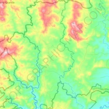
Name: Viguí topographic map, elevation, terrain.
Location: Viguí, Distrito Las Palmas, Veraguas, Panamá (8.26191 -81.53226 8.39870 -81.46809)
Average elevation: 902 ft
Minimum elevation: 367 ft
Maximum elevation: 1,936 ft
Thank you for supporting this site ❤️
Make a donation
Make a donation
Gear up for your next adventure:
As an Amazon Associate, this site earns from qualifying purchases at no extra cost to you.
Other topographic maps
Click on a map to view its topography, its elevation and its terrain.
Cerro Negro
Panamá > Veraguas > Distrito Las Palmas > El Rincón > Cerro Negro
Average elevation: 545 ft