
Make a donation
Gear up for your next adventure:
As an Amazon Associate, this site earns from qualifying purchases at no extra cost to you.
Amuntai topographic map
Click on the map to display elevation.
Make a donation
Gear up for your next adventure:
As an Amazon Associate, this site earns from qualifying purchases at no extra cost to you.
About this map
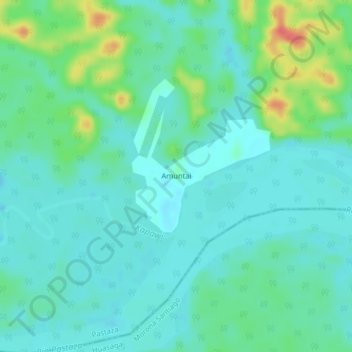
Name: Amuntai topographic map, elevation, terrain.
Location: Amuntai, Montalvo (Andoas), Pastaza, Ecuador (-2.55978 -76.85949 -2.51978 -76.81949)
Average elevation: 837 ft
Minimum elevation: 791 ft
Maximum elevation: 981 ft
Make a donation
Gear up for your next adventure:
As an Amazon Associate, this site earns from qualifying purchases at no extra cost to you.
Other topographic maps
Click on a map to view its topography, its elevation and its terrain.
Puyo
Puyo (Spanish pronunciation: [ˈpuʝo]), also known as El Puyo, is the capital of Pastaza, a province in Ecuador. Puyo is located at an altitude of approximately 950 metres above sea level by the Puyo River, a tributary of the Pastaza River, which eventually leads into the Amazon River. True to its name,…
Average elevation: 3,353 ft
Make a donation
Gear up for your next adventure:
As an Amazon Associate, this site earns from qualifying purchases at no extra cost to you.