Geolocate

Crossdoney topographic map

Interactive map

Click on the map to display elevation.

About this map

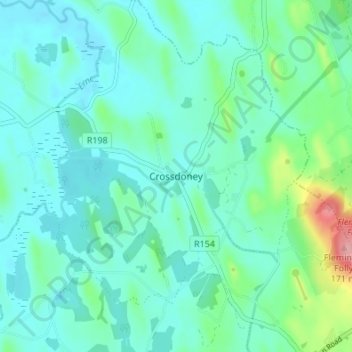
Name: Crossdoney topographic map, elevation, terrain.

Location: Crossdoney, Ballyjamesduff Municipal District, County Cavan, H12 K727, Ireland (53.93415 -7.45534 53.97415 -7.41534)

Average elevation: 220 ft

Minimum elevation: 144 ft

Maximum elevation: 548 ft

Other topographic maps

Click on a map to view its topography, its elevation and its terrain.

Callanagh Lower

Ireland > County Cavan

Callanagh Lower, Drumlumman ED, Ballyjamesduff Municipal District, County Cavan, Ulster, Ireland

Average elevation: 279 ft

Virginia

Ireland > County Cavan

Virginia, Virginia ED, Ballyjamesduff Municipal District, County Cavan, Ireland

Average elevation: 322 ft

Bailieborough

Ireland > County Cavan

Bailieborough, Bailieborough ED, Bailieborough-Cootehill Municipal District, County Cavan, A82 NX86, Ireland

Average elevation: 531 ft

Shercock

Ireland > County Cavan

Shercock, Shercock ED, Bailieborough-Cootehill Municipal District, County Cavan, Ulster, A81 DK60, Ireland

Average elevation: 384 ft

Mount Nugent

Ireland > County Cavan

Mount Nugent, Ballyjamesduff Municipal District, County Cavan, Ulster, Ireland

Average elevation: 243 ft

Ballyjamesduff

Ireland > County Cavan

Ballyjamesduff, Ballyjamesduff Municipal District, County Cavan, Ulster, A82 CT95, Ireland

Average elevation: 387 ft

Ballyconnell

Ireland > County Cavan

Ballyconnell, Ballyconnell ED, Cavan-Belturbet Municipal District, County Cavan, Ulster, H14 EC99, Ireland

Average elevation: 223 ft

Cootehill

Ireland > County Cavan

Cootehill, Bailieborough-Cootehill Municipal District, County Cavan, Ulster, Ireland

Average elevation: 292 ft

Cornafean

Ireland > County Cavan

Cornafean, Ballyjamesduff Municipal District, County Cavan, Ulster, Ireland

Average elevation: 269 ft

Killashandra

Ireland > County Cavan

Killashandra, Killashandra ED, Cavan-Belturbet Municipal District, County Cavan, Ulster, Ireland

Average elevation: 203 ft

Loch Gowna (Scrabby)

Ireland > County Cavan

Loch Gowna (Scrabby), Scrabby ED, Ballyjamesduff Municipal District, County Cavan, Ulster, Ireland

Average elevation: 262 ft

Snugborough

Ireland > County Cavan

Snugborough, Ballyconnell ED, Cavan-Belturbet Municipal District, County Cavan, Ulster, Ireland

Average elevation: 571 ft

Tullycoe

Ireland > County Cavan

Tullycoe, Larah North ED, Bailieborough-Cootehill Municipal District, County Cavan, Ulster, Ireland

Average elevation: 315 ft

Togher or Danesfort Demesne

Ireland > County Cavan

Togher or Danesfort Demesne, Killykeen ED, Cavan-Belturbet Municipal District, County Cavan, Ulster, Ireland

Average elevation: 210 ft

Corfad

Ireland > County Cavan

Corfad, Stradone ED, Bailieborough-Cootehill Municipal District, County Cavan, Ireland

Average elevation: 427 ft

Lisdaran

Ireland > County Cavan

Lisdaran, Cavan Rural ED, Cavan-Belturbet Municipal District, County Cavan, Ulster, Ireland

Average elevation: 240 ft

Cormeen

Ireland > County Cavan

Cormeen, Larah South ED, Bailieborough-Cootehill Municipal District, County Cavan, Ulster, Ireland

Average elevation: 436 ft

Monaghanoose

Ireland > County Cavan

Monaghanoose, Drumanespick ED, Bailieborough-Cootehill Municipal District, County Cavan, Ireland

Average elevation: 459 ft

Bailieborough

Ireland > County Cavan

Bailieborough, Bailieborough-Cootehill Municipal District, County Cavan, Ulster, A82 NX86, Ireland

Average elevation: 535 ft

Cleffin

Ireland > County Cavan

Cleffin, Killinkere ED, Bailieborough-Cootehill Municipal District, County Cavan, Ulster, Ireland

Average elevation: 420 ft

Bailieborough

Ireland > County Cavan > Bailieborough

Bailieborough, Bailieborough-Cootehill Municipal District, County Cavan, A82 NX86, Ireland

Average elevation: 554 ft

Seefin

Ireland > County Cavan

Seefin, Drumanespick ED, Bailieborough-Cootehill Municipal District, County Cavan, Ireland

Average elevation: 636 ft

Kilnavert

Ireland > County Cavan

Kilnavert, Ballymagauran ED, Cavan-Belturbet Municipal District, County Cavan, Ireland

Average elevation: 223 ft

Killaghaduff

Ireland > County Cavan

Killaghaduff, Swanlinbar ED, Cavan-Belturbet Municipal District, County Cavan, Ireland

Average elevation: 299 ft

Drumgart

Ireland > County Cavan

Drumgart, Ardue ED, Cavan-Belturbet Municipal District, County Cavan, Ireland

Average elevation: 180 ft

Cornamucklagh

Ireland > County Cavan > Cornamucklagh

Cornamucklagh, Crossdoney ED, Ballyjamesduff Municipal District, County Cavan, H12K727, Ireland

Average elevation: 200 ft

Bailieborough-Cootehill Municipal District

Ireland > County Cavan

Bailieborough-Cootehill Municipal District, County Cavan, Ulster, Ireland

Average elevation: 400 ft

Carrickallen

Ireland > County Cavan

Carrickallen, Larah North ED, Bailieborough-Cootehill Municipal District, County Cavan, Ireland

Average elevation: 607 ft

Templeport

Ireland > County Cavan

Templeport, County Cavan, Ireland

Average elevation: 531 ft

Dunaree

Ireland > County Cavan

Dunaree, Kingscourt ED, Bailieborough-Cootehill Municipal District, County Cavan, Ireland

Average elevation: 377 ft

Laraweehan

Ireland > County Cavan

Laraweehan, Knappagh ED, Bailieborough-Cootehill Municipal District, County Cavan, Ireland

Average elevation: 341 ft

Drumlane

Ireland > County Cavan

Drumlane, Drung ED, Bailieborough-Cootehill Municipal District, County Cavan, Ireland

Average elevation: 305 ft

Cavan-Belturbet Municipal District

Ireland > County Cavan

Cavan-Belturbet Municipal District, County Cavan, Ulster, Ireland

Average elevation: 364 ft

Glangevlin

Ireland > County Cavan

Glangevlin, Cavan-Belturbet Municipal District, County Cavan, Ulster, Ireland

Average elevation: 607 ft

Kilcogy

Ireland > County Cavan

Kilcogy, Ballyjamesduff Municipal District, County Cavan, Ulster, Ireland

Average elevation: 292 ft