Geolocate

Pōkeno topographic map

Click on the map to display elevation.

About this map

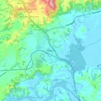
Name: Pōkeno topographic map, elevation, terrain.

Location: Pōkeno, Waikato District, Waikato, 2472, New Zealand (-37.28482 174.98195 -37.20482 175.06195)

Average elevation: 217 ft

Minimum elevation: 10 ft

Maximum elevation: 1,178 ft

Gear up for your next adventure:

🦶Hiking Gaiters - Keep debris and water out of your boots
🥘Titanium Cookware - Durable, featherlight pots and pans for backpacking
🧺Microfiber Travel Towels - Compact and fast-drying towels for trail use
🧷Carabiner Set - Durable clips for gear attachment
🪑Portable Camp Table - Compact table for campsite meals

As an Amazon Associate, this site earns from qualifying purchases at no extra cost to you.