
Make a donation
Gear up for your next adventure:
As an Amazon Associate, this site earns from qualifying purchases at no extra cost to you.
Natanz County topographic map
Click on the map to display elevation.
Make a donation
Gear up for your next adventure:
As an Amazon Associate, this site earns from qualifying purchases at no extra cost to you.
About this map
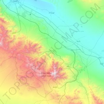
Name: Natanz County topographic map, elevation, terrain.
Location: Natanz County, Isfahan Province, 87661-37751, Iran (33.25193 51.41826 33.96827 52.34117)
Average elevation: 5,610 ft
Minimum elevation: 3,022 ft
Maximum elevation: 12,438 ft
Make a donation
Gear up for your next adventure:
As an Amazon Associate, this site earns from qualifying purchases at no extra cost to you.
Other topographic maps
Click on a map to view its topography, its elevation and its terrain.
Muteh
Iran > Isfahan Province > Shahin Shahr and Meymeh County > Zarkan RD
Average elevation: 6,302 ft
Hasan Abad
Iran > Isfahan Province > Khansar County > دهستان گلسار
Golpayegan (Persian: گلپایگان)) is a city in the Central District of Golpayegan County, Isfahan province, Iran, serving as capital of both the county and the district. The city is 186 kilometres (116 mi) northwest of Isfahan and 102 kilometres (63 mi) southeast of Arak, at an altitude of 1,830 m. Its…
Average elevation: 7,014 ft
Make a donation
Gear up for your next adventure:
As an Amazon Associate, this site earns from qualifying purchases at no extra cost to you.
Make a donation
Gear up for your next adventure:
As an Amazon Associate, this site earns from qualifying purchases at no extra cost to you.
Aran va Bidgol
Iran > Isfahan Province > Aran and Bidgol County > دهستان سفید دشت > Aran va Bidgol
Average elevation: 2,982 ft
Murchehkhort
Iran > Isfahan Province > Shahin Shahr and Meymeh County > دهستان مورچه خورت > Murchehkhort
Average elevation: 5,492 ft
Make a donation
Gear up for your next adventure:
As an Amazon Associate, this site earns from qualifying purchases at no extra cost to you.