Geolocate

Town of Plymouth topographic map

Interactive map

Click on the map to display elevation.

About this map

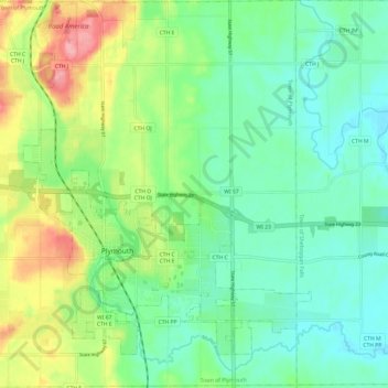
Name: Town of Plymouth topographic map, elevation, terrain.

Location: Town of Plymouth, Sheboygan County, Wisconsin, United States (43.71773 -88.04120 43.80489 -87.92120)

Average elevation: 843 ft

Minimum elevation: 728 ft

Maximum elevation: 1,089 ft

Routes: Sheboygan County GPS tracks, routes, trails, hikes

Other topographic maps

Click on a map to view its topography, its elevation and its terrain.

Town of Mitchell

United States > Wisconsin > Sheboygan County

Average elevation: 1,066 ft

Cedar Grove

United States > Wisconsin > Sheboygan County

Average elevation: 709 ft

Plymouth

United States > Wisconsin > Sheboygan County

Average elevation: 869 ft

Sheboygan

United States > Wisconsin > Sheboygan County > Sheboygan

Average elevation: 617 ft

Random Lake

United States > Wisconsin > Sheboygan County

Average elevation: 892 ft

Town of Scott

United States > Wisconsin > Sheboygan County

Average elevation: 955 ft

Cascade

United States > Wisconsin > Sheboygan County

Average elevation: 906 ft

Elkhart Lake

United States > Wisconsin > Sheboygan County

Average elevation: 948 ft

Kohler

United States > Wisconsin > Sheboygan County > Kohler

Average elevation: 673 ft

Adell

United States > Wisconsin > Sheboygan County > Adell

Average elevation: 912 ft

Town of Rhine

United States > Wisconsin > Sheboygan County

Average elevation: 928 ft