Geolocate

Angola topographic map

Click on the map to display elevation.

About this map

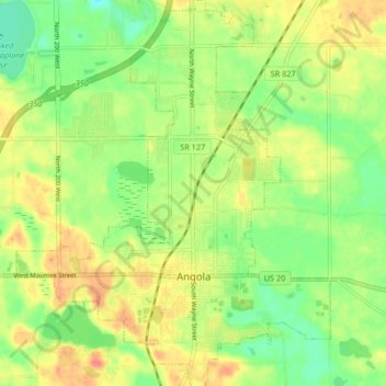
Name: Angola topographic map, elevation, terrain.

Location: Angola, Steuben County, Indiana, United States (41.61720 -85.03736 41.67915 -84.96990)

Average elevation: 1,033 ft

Minimum elevation: 951 ft

Maximum elevation: 1,122 ft

Steuben County trails, hiking, mountain biking, running and outdoor activities

Other topographic maps

Click on a map to view its topography, its elevation and its terrain.

Pleasant Lake

United States > Indiana > Steuben County

Average elevation: 974 ft

Moonlight

United States > Indiana > Steuben County

Average elevation: 974 ft

Lake James

United States > Indiana > Steuben County

Average elevation: 994 ft

Circle Park

United States > Indiana > Steuben County > Hamilton

Average elevation: 932 ft

Gear up for your next adventure:

🛌Ultralight Sleeping Bags - Compact down bags for cold nights in the wilderness
👟Men's Trail Runners - Lightweight footwear for fast-paced exploration and light hiking
☀️Outdoor Sunscreen - High protection sunscreen for outdoor activities
📱Heavy-Duty Phone Cases - Drop-proof and waterproof protection for outdoor navigation
🌲Outdoor Survival Books - Best books on survival skills

As an Amazon Associate, this site earns from qualifying purchases at no extra cost to you.