
Make a donation
Gear up for your next adventure:
As an Amazon Associate, this site earns from qualifying purchases at no extra cost to you.
Jutogh topographic map
Click on the map to display elevation.
Make a donation
Gear up for your next adventure:
As an Amazon Associate, this site earns from qualifying purchases at no extra cost to you.
Jutogh
Jutogh is located at 31°06′N 77°07′E / 31.1°N 77.12°E / 31.1; 77.12 near Totu, an important suburb of Shimla city. It has an average elevation of 1729 metres (5673 feet), a total green area of 112.62 Acres, and a public garden known as Cantt. Board Public Garden.
Make a donation
Gear up for your next adventure:
As an Amazon Associate, this site earns from qualifying purchases at no extra cost to you.
About this map
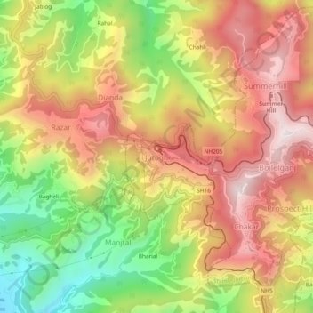
Name: Jutogh topographic map, elevation, terrain.
Average elevation: 5,856 ft
Minimum elevation: 4,426 ft
Maximum elevation: 7,054 ft
Make a donation
Gear up for your next adventure:
As an Amazon Associate, this site earns from qualifying purchases at no extra cost to you.