Geolocate

McCalla topographic map

Click on the map to display elevation.

About this map

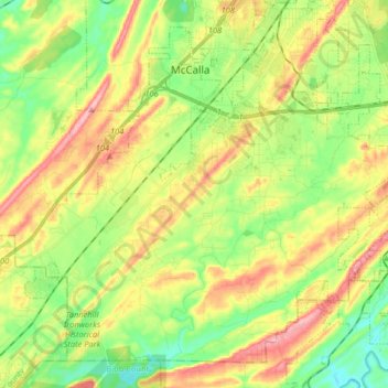
Name: McCalla topographic map, elevation, terrain.

Location: McCalla, Jefferson County, Alabama, United States (33.24643 -87.11102 33.36361 -86.94886)

Average elevation: 548 ft

Minimum elevation: 348 ft

Maximum elevation: 814 ft

Jefferson County trails, hiking, mountain biking, running and outdoor activities

Gear up for your next adventure:

Backpacking Tent - Lightweight and durable tent for multi‑day hikes
🦶Hiking Gaiters - Keep debris and water out of your boots
🏔️Mountain Trail Maps - High‑detail maps for popular peaks
🔥Plasma Lighters - Windproof lighters that work in any weather condition
🧼Biodegradable Camping Soap - Eco‑friendly soap for outdoor hygiene

As an Amazon Associate, this site earns from qualifying purchases at no extra cost to you.