Geolocate

Eden topographic map

Click on the map to display elevation.

About this map

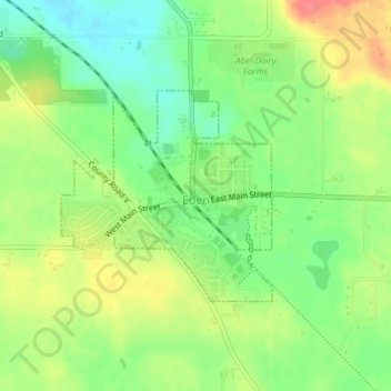
Name: Eden topographic map, elevation, terrain.

Location: Eden, Fond du Lac County, Wisconsin, United States (43.68567 -88.37572 43.70024 -88.35560)

Average elevation: 1,040 ft

Minimum elevation: 942 ft

Maximum elevation: 1,158 ft

Fond du Lac County trails, hiking, mountain biking, running and outdoor activities

Other topographic maps

Click on a map to view its topography, its elevation and its terrain.

Waucousta

United States > Wisconsin > Fond du Lac County

Average elevation: 1,037 ft

Eldorado

United States > Wisconsin > Fond du Lac County

Average elevation: 876 ft

Saint Peter

United States > Wisconsin > Fond du Lac County

Average elevation: 997 ft

Fond du Lac

United States > Wisconsin > Fond du Lac County

Average elevation: 915 ft

Marytown

United States > Wisconsin > Fond du Lac County > Marytown

Average elevation: 955 ft

Gear up for your next adventure:

🪶Camp Gear Gift Set - Perfect gift bundle for outdoor fans
📷Action Camera - Capture your outdoor adventures in HD
🔦Powerful Headlamps - Ultra-bright hands-free lighting for night navigation
Backpacking Tents - Weight-optimized shelters for multi-day topographic surveys
📶Satellite Messenger - Communication device off‑grid

As an Amazon Associate, this site earns from qualifying purchases at no extra cost to you.