
Thank you for supporting this site ❤️
Make a donation
Make a donation
Gear up for your next adventure:
As an Amazon Associate, this site earns from qualifying purchases at no extra cost to you.
Cahorday topographic map
Click on the map to display elevation.
Thank you for supporting this site ❤️
Make a donation
Make a donation
Gear up for your next adventure:
As an Amazon Associate, this site earns from qualifying purchases at no extra cost to you.
About this map
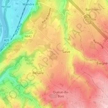
Name: Cahorday topographic map, elevation, terrain.
Location: Cahorday, Saive, Blegny, Luik, Wallonië, 4670, België (50.63174 5.65488 50.67174 5.69488)
Average elevation: 554 ft
Minimum elevation: 177 ft
Maximum elevation: 853 ft
Thank you for supporting this site ❤️
Make a donation
Make a donation
Gear up for your next adventure:
As an Amazon Associate, this site earns from qualifying purchases at no extra cost to you.