Geolocate

Arena topographic map

Click on the map to display elevation.

About this map

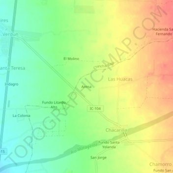
Name: Arena topographic map, elevation, terrain.

Location: Arena, Las Huacas, El Carmen, Chincha, Ica, Peru (-13.51191 -76.14078 -13.47191 -76.10078)

Average elevation: 243 ft

Minimum elevation: 151 ft

Maximum elevation: 341 ft

Gear up for your next adventure:

GPS Sports Watch - GPS watch for running, hiking and training
🗺️Topographic Maps - Detailed topo maps for hiking, exploring and outdoor navigation
👓Polarized Sunglasses - Outdoor sunglasses for glare reduction
🔌Solar Panel Charger - Charge gear sustainably outdoors
🏕️Tent Footprint - Protect your tent base from wear

As an Amazon Associate, this site earns from qualifying purchases at no extra cost to you.