
Henry Mountains topographic map
Click on the map to display elevation.
About this map
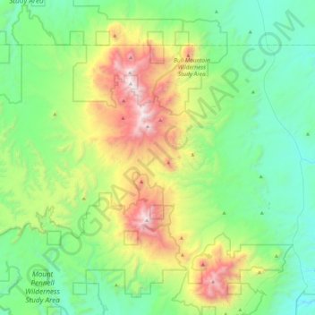
Name: Henry Mountains topographic map, elevation, terrain.
Location: Henry Mountains, Garfield County, Utah, United States (37.84938 -110.89874 38.20150 -110.60211)
Average elevation: 6,352 ft
Minimum elevation: 4,416 ft
Maximum elevation: 11,490 ft
Garfield County trails, hiking, mountain biking, running and outdoor activities
Other topographic maps
Click on a map to view its topography, its elevation and its terrain.
Panguitch
United States > Utah > Garfield County
Panguitch has a cool semi-arid climate (Köppen BSk) with summers featuring hot afternoons and cold mornings, and cold, dry winters. The high altitude and relatively high latitude means that mornings are cold throughout the year and freezing for most of it: between 1971 and 2000 an average of 227.7 mornings…
Average elevation: 6,703 ft
Bryce Canyon National Park
United States > Utah > Garfield County
Bryce Canyon National Park (/braɪs/) is an American national park located in southwestern Utah. The major feature of the park is Bryce Canyon, which despite its name, is not a canyon, but a collection of giant natural amphitheaters along the eastern side of the Paunsaugunt Plateau. Bryce is distinctive due to…
Average elevation: 7,411 ft
Mount Ellen
United States > Utah > Garfield County
Mount Ellen is an ultra prominent peak, meaning that it has more than 1,500 metres (4,921 ft) of topographic prominence, standing out considerably from nearby mountains. It stands in the watershed of the Fremont River, which together with Muddy Creek forms the Dirty Devil River, which drains into the Colorado…
Average elevation: 10,331 ft
Escalante Petrified Forest State Park
United States > Utah > Garfield County > Escalante
Average elevation: 6,010 ft
Bryce Canyon National Park
United States > Utah > Garfield County
Bryce Canyon National Park (/braɪs/) is an American national park located in southwestern Utah. The major feature of the park is Bryce Canyon, which despite its name, is not a canyon, but a collection of giant natural amphitheaters along the eastern side of the Paunsaugunt Plateau. Bryce is distinctive due to…
Average elevation: 7,411 ft
Panguitch
United States > Utah > Garfield County
Panguitch has a cool semi-arid climate (Köppen BSk) with summers featuring hot afternoons and cold mornings, and cold, dry winters. The high altitude and relatively high latitude means that mornings are cold throughout the year and freezing for most of it: between 1971 and 2000 an average of 227.7 mornings…
Average elevation: 6,703 ft