
Make a donation
Gear up for your next adventure:
As an Amazon Associate, this site earns from qualifying purchases at no extra cost to you.
Boulder topographic map
Click on the map to display elevation.
Make a donation
Gear up for your next adventure:
As an Amazon Associate, this site earns from qualifying purchases at no extra cost to you.
About this map
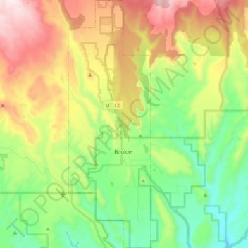
Name: Boulder topographic map, elevation, terrain.
Location: Boulder, Garfield County, Utah, 84716, United States (37.85752 -111.46025 37.98794 -111.40524)
Average elevation: 6,939 ft
Minimum elevation: 5,725 ft
Maximum elevation: 8,839 ft
Garfield County trails, hiking, mountain biking, running and outdoor activities
Make a donation
Gear up for your next adventure:
As an Amazon Associate, this site earns from qualifying purchases at no extra cost to you.
Other topographic maps
Click on a map to view its topography, its elevation and its terrain.
Mount Ellen
United States > Utah > Garfield County
Mount Ellen is an ultra prominent peak, meaning that it has more than 1,500 metres (4,921 ft) of topographic prominence, standing out considerably from nearby mountains. It stands in the watershed of the Fremont River, which together with Muddy Creek forms the Dirty Devil River, which drains into the Colorado…
Average elevation: 10,331 ft
Make a donation
Gear up for your next adventure:
As an Amazon Associate, this site earns from qualifying purchases at no extra cost to you.
Make a donation
Gear up for your next adventure:
As an Amazon Associate, this site earns from qualifying purchases at no extra cost to you.