
Make a donation
Gear up for your next adventure:
As an Amazon Associate, this site earns from qualifying purchases at no extra cost to you.
Todtenhausen topographic map
Click on the map to display elevation.
Make a donation
Gear up for your next adventure:
As an Amazon Associate, this site earns from qualifying purchases at no extra cost to you.
Todtenhausen
1649 kam die „Bauerschaft Todtenhausen“ zu Brandenburg-Preußen (Huldigung des Großen Kurfürsten im Jahre 1650 im Schloss zu Petershagen). Die 1682 bestehenden 41 Höfe wurden nach der Höhe ihrer Ablieferungspflicht fortlaufend nummeriert. Daraus entstanden die ersten Hausnummern. Todtenhausen war dem Schloss zu Petershagen gegenüber spanndienstpflichtig (1733).
Make a donation
Gear up for your next adventure:
As an Amazon Associate, this site earns from qualifying purchases at no extra cost to you.
About this map
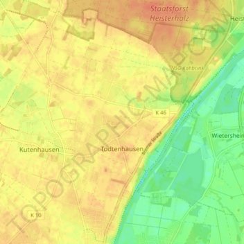
Name: Todtenhausen topographic map, elevation, terrain.
Average elevation: 180 ft
Minimum elevation: 98 ft
Maximum elevation: 230 ft
Make a donation
Gear up for your next adventure:
As an Amazon Associate, this site earns from qualifying purchases at no extra cost to you.
Other topographic maps
Click on a map to view its topography, its elevation and its terrain.
Häverstädt
Deutschland > Nordrhein-Westfalen > Kreis Minden-Lübbecke > Minden
Average elevation: 299 ft