Schneeberg topographic map
Interactive map
Click on the map to display elevation.
About this map
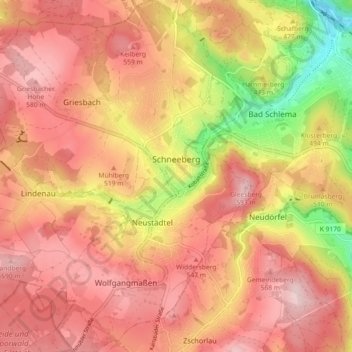
Name: Schneeberg topographic map, elevation, terrain.
Location: Schneeberg, Erzgebirgskreis, Saxony, 08289, Germany (50.56338 12.57566 50.62110 12.66030)
Average elevation: 1,637 ft
Minimum elevation: 1,073 ft
Maximum elevation: 1,955 ft
Other topographic maps
Click on a map to view its topography, its elevation and its terrain.
Marienberg
Germany > Saxony > Erzgebirgskreis
Marienberg, Erzgebirgskreis, Saxony, 09496, Germany
Average elevation: 2,156 ft
Kühnhaide
Germany > Saxony > Erzgebirgskreis > Zwönitz
Kühnhaide, Zwönitz, Erzgebirgskreis, Saxony, Germany
Average elevation: 2,001 ft
Mildenau
Germany > Saxony > Erzgebirgskreis
Mildenau, Erzgebirgskreis, Saxony, Germany
Average elevation: 1,988 ft
Rittersgrün
Germany > Saxony > Erzgebirgskreis > Breitenbrunn/Erzgebirge
Rittersgrün, Breitenbrunn/Erzgebirge, Erzgebirgskreis, Saxony, 08359, Germany
Average elevation: 2,379 ft
Ehrenfriedersdorf
Germany > Saxony > Erzgebirgskreis
Ehrenfriedersdorf, Erzgebirgskreis, Saxony, 09427, Germany
Average elevation: 1,909 ft