
Make a donation
Gear up for your next adventure:
As an Amazon Associate, this site earns from qualifying purchases at no extra cost to you.
Landsrade topographic map
Click on the map to display elevation.
Make a donation
Gear up for your next adventure:
As an Amazon Associate, this site earns from qualifying purchases at no extra cost to you.
Landsrade
De buurtschap ligt op de hoogte van het Plateau van Crapoel tussen de dalen van de Gulp en de Geul. Ten westen van Landsrade begint het Pesakerdal dat richting het noordwesten zich steeds dieper in het plateau insnijdt. Ten oosten van Landsrade snijdt het dal van de Landeus in op het plateau. In dit dal ligt buurtschap Bissen.
Make a donation
Gear up for your next adventure:
As an Amazon Associate, this site earns from qualifying purchases at no extra cost to you.
About this map
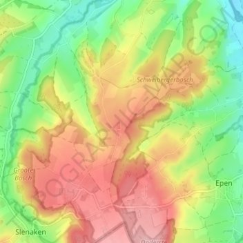
Name: Landsrade topographic map, elevation, terrain.
Average elevation: 545 ft
Minimum elevation: 312 ft
Maximum elevation: 784 ft
Make a donation
Gear up for your next adventure:
As an Amazon Associate, this site earns from qualifying purchases at no extra cost to you.