Geolocate

Fostoria topographic map

Click on the map to display elevation.

About this map

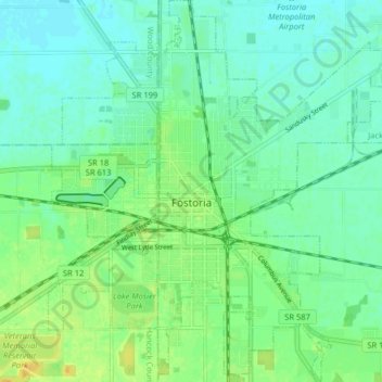
Name: Fostoria topographic map, elevation, terrain.

Location: Fostoria, Seneca County, Ohio, 44830, United States (41.12906 -83.44425 41.18947 -83.37173)

Average elevation: 771 ft

Minimum elevation: 741 ft

Maximum elevation: 820 ft

Seneca County trails, hiking, mountain biking, running and outdoor activities

Other topographic maps

Click on a map to view its topography, its elevation and its terrain.

Mohawk Lake

United States > Ohio > Seneca County

Average elevation: 787 ft

Alvada

United States > Ohio > Seneca County

Average elevation: 843 ft

Old Fort

United States > Ohio > Seneca County

Average elevation: 682 ft

Saint Stephens

United States > Ohio > Seneca County

Average elevation: 948 ft

Gear up for your next adventure:

🥩Freeze-Dried Meals - Nutritious and lightweight food for remote expeditions
🥾Men's Hiking Boots - Durable, waterproof footwear for rugged terrain and steep inclines
🪶Wildlife Field Guides - Learn animal tracking and species ID
🧭Outdoor Navigation Book - Learn advanced navigation skills
🪵Folding Camp Saw - Compact saw for wood and campsite work

As an Amazon Associate, this site earns from qualifying purchases at no extra cost to you.