
Make a donation
Gear up for your next adventure:
As an Amazon Associate, this site earns from qualifying purchases at no extra cost to you.
Gaula topographic map
Click on the map to display elevation.
Make a donation
Gear up for your next adventure:
As an Amazon Associate, this site earns from qualifying purchases at no extra cost to you.
About this map
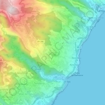
Name: Gaula topographic map, elevation, terrain.
Location: Gaula, Santa Cruz, Madeira, 9100-019, Portugal (32.65153 -16.83456 32.69153 -16.79456)
Average elevation: 748 ft
Minimum elevation: 0 ft
Maximum elevation: 2,516 ft
Make a donation
Gear up for your next adventure:
As an Amazon Associate, this site earns from qualifying purchases at no extra cost to you.
Other topographic maps
Click on a map to view its topography, its elevation and its terrain.
Camacha
A Vila da Camacha é uma freguesia portuguesa do concelho de Santa Cruz, com 19,58 km² de área e 7 449 habitantes (2011). A sua densidade populacional é 380,4 hab/km². Localiza-se a uma latitude 32.7 (32°42') Norte e a uma longitude 16,84 (16°49'20") Oeste, estando a uma altitude de aproximadamente 700…
Average elevation: 2,369 ft
Make a donation
Gear up for your next adventure:
As an Amazon Associate, this site earns from qualifying purchases at no extra cost to you.