Geolocate

Richmond topographic map

Click on the map to display elevation.

About this map

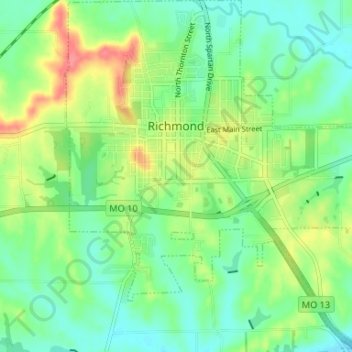
Name: Richmond topographic map, elevation, terrain.

Location: Richmond, Ray County, Missouri, 64085, United States (39.24587 -93.99769 39.29681 -93.93662)

Average elevation: 787 ft

Minimum elevation: 709 ft

Maximum elevation: 935 ft

Ray County trails, hiking, mountain biking, running and outdoor activities

Other topographic maps

Click on a map to view its topography, its elevation and its terrain.

Vibbard

United States > Missouri > Ray County

Average elevation: 1,010 ft

Gear up for your next adventure:

🛶Inflatable Kayak - Portable kayak for rivers, lakes, and expeditions
🏫Relief Map Kits - Hands-on tools for teaching landforms and elevation
📦Gear Storage Bags - Organize and protect outdoor equipment
💧Water Filtration Bottles - Safely drink from streams and lakes while exploring
🌐World Map Poster - Decorative world maps with topographic info

As an Amazon Associate, this site earns from qualifying purchases at no extra cost to you.