Geolocate

Hope topographic map

Click on the map to display elevation.

Hope

Hope is located at 48°14′55″N 116°18′33″W / 48.24861°N 116.30917°W / 48.24861; -116.30917 (48.248728, -116.309214), at an elevation of 2,192 feet (668 m) above sea level. The city sits on the northeast shore of Lake Pend Oreille.

Wikipedia (CC-BY-SA 3.0)

About this map

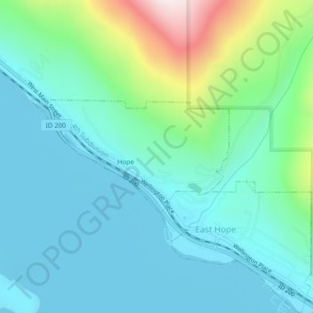
Name: Hope topographic map, elevation, terrain.

Location: Hope, Bonner County, Idaho, United States (48.24320 -116.31929 48.25306 -116.29371)

Average elevation: 2,503 ft

Minimum elevation: 2,041 ft

Maximum elevation: 4,252 ft

Bonner County trails, hiking, mountain biking, running and outdoor activities

Other topographic maps

Click on a map to view its topography, its elevation and its terrain.

Cocolalla

United States > Idaho > Bonner County

Average elevation: 2,474 ft

Lake Cocolalla

United States > Idaho > Bonner County

Average elevation: 2,398 ft

Scotchman Peak

United States > Idaho > Bonner County

Average elevation: 5,666 ft

Vay

United States > Idaho > Bonner County

Average elevation: 2,290 ft

Lignite

United States > Idaho > Bonner County

Average elevation: 2,264 ft

Sagle

United States > Idaho > Bonner County

Average elevation: 2,224 ft

Blanchard

United States > Idaho > Bonner County

Average elevation: 2,356 ft

Blanchard

United States > Idaho > Bonner County

Average elevation: 2,356 ft

Gear up for your next adventure:

🧭Pro Hiking Compasses - High-accuracy liquid-filled compasses for topographic orientation
🦶Hiking Gaiters - Keep debris and water out of your boots
🪶Compact Camp Shovel - Folding shovel for campsite tasks
💧Water Purification System - Clean water on the trail with reliable purifiers
🧺Microfiber Travel Towels - Compact and fast-drying towels for trail use

As an Amazon Associate, this site earns from qualifying purchases at no extra cost to you.