
Make a donation
Gear up for your next adventure:
As an Amazon Associate, this site earns from qualifying purchases at no extra cost to you.
Center Township topographic map
Click on the map to display elevation.
Make a donation
Gear up for your next adventure:
As an Amazon Associate, this site earns from qualifying purchases at no extra cost to you.
About this map
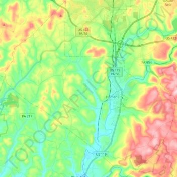
Name: Center Township topographic map, elevation, terrain.
Location: Center Township, Indiana County, Pennsylvania, United States (40.47968 -79.27696 40.61979 -79.09788)
Average elevation: 1,280 ft
Minimum elevation: 958 ft
Maximum elevation: 1,831 ft
Make a donation
Gear up for your next adventure:
As an Amazon Associate, this site earns from qualifying purchases at no extra cost to you.
Other topographic maps
Click on a map to view its topography, its elevation and its terrain.
Robinson
United States > Pennsylvania > Indiana County > West Wheatfield Township
Average elevation: 1,302 ft
Elders Ridge
United States > Pennsylvania > Indiana County > Young Township
Average elevation: 1,201 ft
Make a donation
Gear up for your next adventure:
As an Amazon Associate, this site earns from qualifying purchases at no extra cost to you.