Geolocate

Bridgeport topographic map

Click on the map to display elevation.

About this map

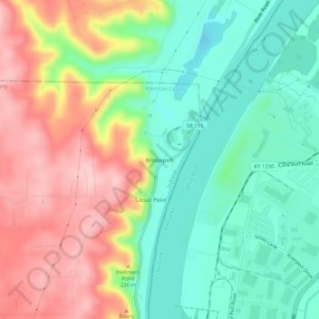
Name: Bridgeport topographic map, elevation, terrain.

Location: Bridgeport, Harrison County, Indiana, United States (38.15618 -85.92635 38.19618 -85.88635)

Average elevation: 607 ft

Minimum elevation: 351 ft

Maximum elevation: 961 ft

Harrison County trails, hiking, mountain biking, running and outdoor activities

Other topographic maps

Click on a map to view its topography, its elevation and its terrain.

Lanesville

United States > Indiana > Harrison County

Average elevation: 784 ft

New Amsterdam

United States > Indiana > Harrison County

Average elevation: 495 ft

New Middletown

United States > Indiana > Harrison County

Average elevation: 705 ft

Crandall

United States > Indiana > Harrison County

Average elevation: 712 ft

Laconia

United States > Indiana > Harrison County

Average elevation: 659 ft

Gear up for your next adventure:

🛰️Handheld GPS Units - Professional satellite navigators for precise backcountry mapping
🏫Relief Map Kits - Hands-on tools for teaching landforms and elevation
📱Solar Portable Charger - Solar power bank for charging devices off‑grid
🔭Telescopic Hiking Pole - Adjustable pole for hiking stability
🌡️Portable Weather Meter - Track weather conditions on the trail

As an Amazon Associate, this site earns from qualifying purchases at no extra cost to you.