
Make a donation
Gear up for your next adventure:
As an Amazon Associate, this site earns from qualifying purchases at no extra cost to you.
Schnarrtanne topographic map
Click on the map to display elevation.
Make a donation
Gear up for your next adventure:
As an Amazon Associate, this site earns from qualifying purchases at no extra cost to you.
Schnarrtanne
In Schnarrtanne bestanden zur DDR-Zeit das Ferienheim des Reichsbahnausbesserungswerks „7. Oktober“ Zwickau, das Betriebsferienlager „Rolf Weinbrecht“ und das Gardelko-Ferienheim in der im Jahr 2014 abgerissenen Gastwirtschaft „Goldene Höhe“.
Make a donation
Gear up for your next adventure:
As an Amazon Associate, this site earns from qualifying purchases at no extra cost to you.
About this map
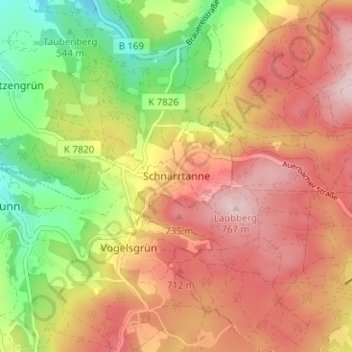
Name: Schnarrtanne topographic map, elevation, terrain.
Average elevation: 2,106 ft
Minimum elevation: 1,598 ft
Maximum elevation: 2,526 ft
Make a donation
Gear up for your next adventure:
As an Amazon Associate, this site earns from qualifying purchases at no extra cost to you.
Other topographic maps
Click on a map to view its topography, its elevation and its terrain.