
Make a donation
Gear up for your next adventure:
As an Amazon Associate, this site earns from qualifying purchases at no extra cost to you.
Edersee topographic map
Click on the map to display elevation.
Make a donation
Gear up for your next adventure:
As an Amazon Associate, this site earns from qualifying purchases at no extra cost to you.
Edersee
Der Edersee, in dem die Eder durch die bei Hemfurth-Edersee (zu Edertal) stehende Staumauer zu einem Stausee aufgestaut wird, befindet sich rund 35 km Luftlinie südwestlich von Kassel und direkt nördlich des Mittelgebirges Kellerwald im Norden des Naturparks Kellerwald-Edersee. Er reicht von der Einmündung der Eder vor Herzhausen (zu Vöhl) im Westen bis zur Staumauer bei Hemfurth-Edersee im Osten und stößt im Süden an die Ederhöhen, einer Bergregion im Norden des Kellerwaldes, die zusammen mit den nördlichen Hängen des Edertrogs den Nationalpark Kellerwald-Edersee bildet.
Make a donation
Gear up for your next adventure:
As an Amazon Associate, this site earns from qualifying purchases at no extra cost to you.
About this map
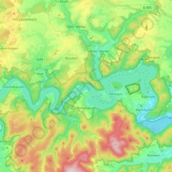
Name: Edersee topographic map, elevation, terrain.
Average elevation: 1,145 ft
Minimum elevation: 650 ft
Maximum elevation: 2,051 ft
Make a donation
Gear up for your next adventure:
As an Amazon Associate, this site earns from qualifying purchases at no extra cost to you.