
Acacías topographic map
Interactive map
Click on the map to display elevation.
About this map
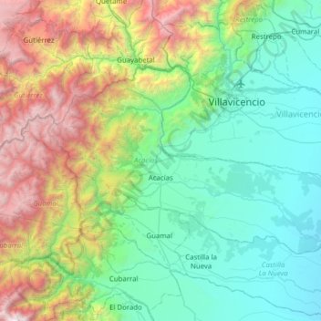
Name: Acacías topographic map, elevation, terrain.
Location: Acacías, Piedemonte, Meta, 507001, Colombie (3.84189 -74.03708 4.20289 -73.41766)
Average elevation: 4,157 ft
Minimum elevation: 915 ft
Maximum elevation: 13,648 ft
Le chef lieu de la municipalité de Acacías porte le même nom et se trouve à l'altitude moyenne de 523 mètres.
Other topographic maps
Click on a map to view its topography, its elevation and its terrain.
Perímetro Urbano Villavicencio
Perímetro Urbano Villavicencio, Villavicencio, Capital, Meta, Colombie
Average elevation: 1,552 ft
Villavicencio
Colombie > Meta > Villavicencio
Villavicencio, Capital, Meta, Colombie
Average elevation: 2,854 ft