
Radcliff topographic map
Interactive map
Click on the map to display elevation.
About this map
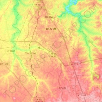
Name: Radcliff topographic map, elevation, terrain.
Location: Radcliff, Hardin County, Kentucky, 40160, United States (37.74857 -85.98154 37.87633 -85.88425)
Average elevation: 732 ft
Minimum elevation: 476 ft
Maximum elevation: 892 ft
Other topographic maps
Click on a map to view its topography, its elevation and its terrain.
Elizabethtown
United States > Kentucky > Hardin County
Elizabethtown, Hardin County, Kentucky, 42701, United States
Average elevation: 791 ft
Limp
United States > Kentucky > Hardin County
Limp, Hardin County, Kentucky, United States
Average elevation: 692 ft
Hardin County
United States > Kentucky > Hardin County
Hardin County, Kentucky, United States
Average elevation: 696 ft
West Point
United States > Kentucky > Hardin County
West Point, Hardin County, Kentucky, United States
Average elevation: 535 ft
Cecil Hill
United States > Kentucky > Hardin County
Cecil Hill, Hardin County, Kentucky, 42724, United States
Average elevation: 755 ft
Kraft
United States > Kentucky > Hardin County
Kraft, Hardin County, Kentucky, 40162, United States
Average elevation: 810 ft
Vine Grove
United States > Kentucky > Hardin County
Vine Grove, Hardin County, Kentucky, United States
Average elevation: 715 ft
West Point
United States > Kentucky > Hardin County > West Point
West Point, Hardin County, Kentucky, 40177, United States
Average elevation: 554 ft