
Cecil Hill topographic map
Interactive map
Click on the map to display elevation.
About this map
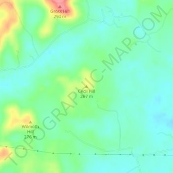
Name: Cecil Hill topographic map, elevation, terrain.
Location: Cecil Hill, Hardin County, Kentucky, 42724, United States (37.65973 -86.04640 37.65983 -86.04630)
Average elevation: 755 ft
Minimum elevation: 676 ft
Maximum elevation: 948 ft
Other topographic maps
Click on a map to view its topography, its elevation and its terrain.
Elizabethtown
United States > Kentucky > Hardin County
Elizabethtown, Hardin County, Kentucky, 42701, United States
Average elevation: 791 ft
Limp
United States > Kentucky > Hardin County
Limp, Hardin County, Kentucky, United States
Average elevation: 692 ft
Hardin County
United States > Kentucky > Hardin County
Hardin County, Kentucky, United States
Average elevation: 696 ft
West Point
United States > Kentucky > Hardin County
West Point, Hardin County, Kentucky, United States
Average elevation: 535 ft
Kraft
United States > Kentucky > Hardin County
Kraft, Hardin County, Kentucky, 40162, United States
Average elevation: 810 ft
Vine Grove
United States > Kentucky > Hardin County
Vine Grove, Hardin County, Kentucky, United States
Average elevation: 715 ft
West Point
United States > Kentucky > Hardin County > West Point
West Point, Hardin County, Kentucky, 40177, United States
Average elevation: 554 ft
Radcliff
United States > Kentucky > Hardin County
Radcliff, Hardin County, Kentucky, 40160, United States
Average elevation: 732 ft