
Make a donation
Gear up for your next adventure:
As an Amazon Associate, this site earns from qualifying purchases at no extra cost to you.
Hoogstraten topographic map
Click on the map to display elevation.
Make a donation
Gear up for your next adventure:
As an Amazon Associate, this site earns from qualifying purchases at no extra cost to you.
Hoogstraten
De Romeinen plachten hun wegen over hoogten aan te leggen. In het Engels duidt het woord highway (Oudengels: heahweg, heahstræte = high street) een hoofdweg aan tussen twee steden en vroeger vooral oude Romeinse wegen die zoals gezegd veelal hooggelegen waren.
Make a donation
Gear up for your next adventure:
As an Amazon Associate, this site earns from qualifying purchases at no extra cost to you.
About this map
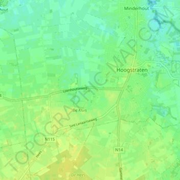
Name: Hoogstraten topographic map, elevation, terrain.
Location: Hoogstraten, Turnhout, Antwerpen, Vlaanderen, 2320, België (51.37555 4.70928 51.41619 4.78532)
Average elevation: 62 ft
Minimum elevation: 33 ft
Maximum elevation: 85 ft
Make a donation
Gear up for your next adventure:
As an Amazon Associate, this site earns from qualifying purchases at no extra cost to you.
Other topographic maps
Click on a map to view its topography, its elevation and its terrain.