Geolocate

Cavoretto topographic map

Click on the map to display elevation.

About this map

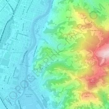
Name: Cavoretto topographic map, elevation, terrain.

Location: Cavoretto, Turin, Torino, Piedmont, 10133, Italy (45.00944 7.66849 45.04944 7.70849)

Average elevation: 1,106 ft

Minimum elevation: 712 ft

Maximum elevation: 2,156 ft

Gear up for your next adventure:

GPS Sports Watch - GPS watch for running, hiking and training
🪶Paracord Bracelet - Survival bracelet with built‑in tools
🌧️Backpack Rain Cover - Keep gear dry in wet weather
🧭GPS Watch Accessories - Bands and chargers for GPS watches
🪵Folding Camp Saw - Compact saw for wood and campsite work

As an Amazon Associate, this site earns from qualifying purchases at no extra cost to you.