
Make a donation
Gear up for your next adventure:
As an Amazon Associate, this site earns from qualifying purchases at no extra cost to you.
Santo André topographic map
Click on the map to display elevation.
Make a donation
Gear up for your next adventure:
As an Amazon Associate, this site earns from qualifying purchases at no extra cost to you.
About this map
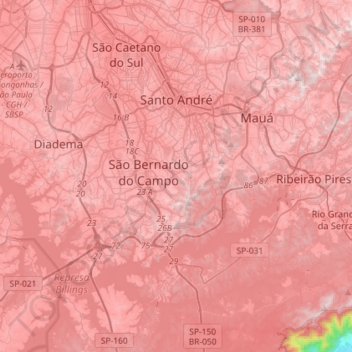
Name: Santo André topographic map, elevation, terrain.
Location: Santo André, São Paulo, Southeast Region, Brazil (-23.81581 -46.56730 -23.60566 -46.27862)
Average elevation: 2,539 ft
Minimum elevation: 13 ft
Maximum elevation: 3,225 ft
Make a donation
Gear up for your next adventure:
As an Amazon Associate, this site earns from qualifying purchases at no extra cost to you.
Other topographic maps
Click on a map to view its topography, its elevation and its terrain.
São Paulo
Brazil > São Paulo > Região Metropolitana de São Paulo > São Paulo
São Paulo is in Southeastern Brazil, in southeastern São Paulo State, approximately halfway between Curitiba and Rio de Janeiro. The city is on a plateau placed beyond the Serra do Mar (Portuguese for "Sea Range" or "Coastal Range"), itself a component of the vast region known as the Brazilian Highlands,…
Average elevation: 2,575 ft
Ilha Sumítica
Brazil > São Paulo > Região Metropolitana do Vale do Paraíba e Litoral Norte > Ilhabela
Average elevation: 3 ft
Ilha da Queimada Grande
Located approximately 33 kilometres (21 mi) off the coast of the state of São Paulo, Brazil, the island of Queimada Grande is approximately 430,000 square metres (106 acres) in area and ranges in elevation from 0 to 206 metres (676 ft) above sea level. It has a temperate climate that is similar to that of its…
Average elevation: 10 ft
Make a donation
Gear up for your next adventure:
As an Amazon Associate, this site earns from qualifying purchases at no extra cost to you.
Ilha Sumítica
Brazil > São Paulo > Região Metropolitana do Vale do Paraíba e Litoral Norte > Ilhabela
Average elevation: 3 ft
Pedra do Baú
Brazil > São Paulo > Região Metropolitana do Vale do Paraíba e Litoral Norte > São Bento do Sapucaí
At its highest point, the elevation is 1,950 metres (6,400 ft).
Average elevation: 4,928 ft
João Aranha
Brazil > São Paulo > Região Metropolitana de Campinas > Paulínia
Average elevation: 1,913 ft
Kobayat Líbano
Brazil > São Paulo > Região Metropolitana de Piracicaba > Piracicaba
Average elevation: 1,709 ft
Make a donation
Gear up for your next adventure:
As an Amazon Associate, this site earns from qualifying purchases at no extra cost to you.
Praça Tenente Roberto Osaki
Brazil > São Paulo > Região Metropolitana de São Paulo > Osasco
Average elevation: 2,398 ft
Morro do Diabo
Brazil > São Paulo > Teodoro Sampaio
Its summit altitude is 650 metres (2,130 ft) (ASL). Morro do Diabo is an area landmark, seen from the valleys and plains below it. It is located near the cities of Caxias do Sul and Porto Alegre, the state capital.
Average elevation: 1,302 ft
Praça Bartolomeu de Messina
Brazil > São Paulo > Região Metropolitana de São Paulo > São Paulo
Average elevation: 2,592 ft
Make a donation
Gear up for your next adventure:
As an Amazon Associate, this site earns from qualifying purchases at no extra cost to you.
Morro do Pico Agudo
Brazil > São Paulo > Região Metropolitana do Vale do Paraíba e Litoral Norte > Paraibuna
Average elevation: 3,465 ft
Sitio Borda da Mata
Brazil > São Paulo > Região Metropolitana de São Paulo > Franco da Rocha
Average elevation: 2,602 ft
Serra do Roncador
Brazil > São Paulo > Região Metropolitana do Vale do Paraíba e Litoral Norte > Monteiro Lobato
Average elevation: 2,776 ft
Nova Piracicaba
Brazil > São Paulo > Região Metropolitana de Piracicaba > Piracicaba
Average elevation: 1,617 ft
Make a donation
Gear up for your next adventure:
As an Amazon Associate, this site earns from qualifying purchases at no extra cost to you.
Praça Barão do Rio Branco
Brazil > São Paulo > Região Metropolitana do Vale do Paraíba e Litoral Norte > Jacareí
Average elevation: 1,906 ft
Ilha Sumítica
Brazil > São Paulo > Região Metropolitana do Vale do Paraíba e Litoral Norte > Ilhabela
Average elevation: 3 ft
Mirante Rio Piracicaba
Brazil > São Paulo > Região Metropolitana de Piracicaba > Piracicaba
Average elevation: 1,657 ft
Paiol Grande
Brazil > São Paulo > Região Metropolitana do Vale do Paraíba e Litoral Norte > São Bento do Sapucaí
Average elevation: 4,393 ft
Make a donation
Gear up for your next adventure:
As an Amazon Associate, this site earns from qualifying purchases at no extra cost to you.
Bairro Planalto do Sul
Brazil > São Paulo > Mirante do Paranapanema > Bairro Planalto do Sul
Average elevation: 1,434 ft
Sorocaba
Brazil > São Paulo > Região Metropolitana de Sorocaba > Sorocaba
The terrain is classified as a wavy strands and characterized by local ridges, with an average altitude of 632 meters above the sea level. The highest altitude is 1028 meters, in the Serra de Sao Francisco. The lower altitude is 539 meters, in the valley of the Sorocaba River. Sorocaba is located on the edge…
Average elevation: 2,172 ft
Make a donation
Gear up for your next adventure:
As an Amazon Associate, this site earns from qualifying purchases at no extra cost to you.
Mogi Mirim
Brazil > São Paulo > Mogi Mirim
Mogi Mirim is a municipality located in the eastern part of São Paulo State, in Brazil. The population is 93,650 (2020 est.) in an area of 498 km². The elevation is 611 m.
Average elevation: 2,149 ft
Santo André
Brazil > São Paulo > Região Metropolitana de São Paulo > Santo André
Average elevation: 2,546 ft
Make a donation
Gear up for your next adventure:
As an Amazon Associate, this site earns from qualifying purchases at no extra cost to you.
São José dos Campos
Brazil > São Paulo > Região Metropolitana do Vale do Paraíba e Litoral Norte
In the urban area, there are rolling plateaus and hills. The lowest elevation in the city (and also in the municipality) is found in the Paraíba do Sul River, at a mean elevation of 550 m.
Average elevation: 2,080 ft
São Bernardo do Campo
Brazil > São Paulo > Região Metropolitana de São Paulo > São Bernardo do Campo
Average elevation: 2,493 ft
Make a donation
Gear up for your next adventure:
As an Amazon Associate, this site earns from qualifying purchases at no extra cost to you.
Rio Paraíba do Sul
Brazil > São Paulo > Região Metropolitana do Vale do Paraíba e Litoral Norte > Guaratinguetá
Average elevation: 1,791 ft