
Make a donation
Gear up for your next adventure:
As an Amazon Associate, this site earns from qualifying purchases at no extra cost to you.
Taumarunui topographic map
Click on the map to display elevation.
Make a donation
Gear up for your next adventure:
As an Amazon Associate, this site earns from qualifying purchases at no extra cost to you.
Taumarunui
Under the Köppen, Taumarunui has an Oceanic climate:(Cfb). Due to location, low altitude and Geography surroundings, Taumarunui is more liable to warm to hot summers than other central North Island centres and in winter, Taumarunui is cold and frosty. Rainfall yearly is 1,449 mm (57.047244 in). Annual sunshine yearly is 1822 hrs. In June 2002, Taumarunui recorded just 27 hrs of sun, this is the lowest in the whole country, beating the old record at Invercargill with 35 hrs in June 1935. The lowest temperature recorded in Taumarunui, −6.8 °C, was in July 2010.
Make a donation
Gear up for your next adventure:
As an Amazon Associate, this site earns from qualifying purchases at no extra cost to you.
About this map
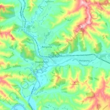
Name: Taumarunui topographic map, elevation, terrain.
Average elevation: 804 ft
Minimum elevation: 486 ft
Maximum elevation: 1,486 ft
Make a donation
Gear up for your next adventure:
As an Amazon Associate, this site earns from qualifying purchases at no extra cost to you.