Geolocate

Dorr topographic map

Click on the map to display elevation.

About this map

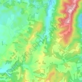
Name: Dorr topographic map, elevation, terrain.

Location: Dorr, Monroe County, West Virginia, 24976, United States (37.59957 -80.49396 37.63957 -80.45396)

Average elevation: 2,372 ft

Minimum elevation: 2,096 ft

Maximum elevation: 2,802 ft

Monroe County trails, hiking, mountain biking, running and outdoor activities

Other topographic maps

Click on a map to view its topography, its elevation and its terrain.

Peterstown

United States > West Virginia > Monroe County

Average elevation: 1,775 ft

Gear up for your next adventure:

👖Convertible Hiking Pants - Versatile zip-off pants for changing altitudes and temperatures
🦶Carbon Trekking Poles - Reduce knee impact on steep descents with ultra-light poles
🪶Compact Camp Shovel - Folding shovel for campsite tasks
🗺️Topographic Maps - Detailed topo maps for hiking, exploring and outdoor navigation
🥇GPS Hiking Watch - Multi‑sport GPS watch with navigation and trail tracking

As an Amazon Associate, this site earns from qualifying purchases at no extra cost to you.