
Make a donation
Gear up for your next adventure:
As an Amazon Associate, this site earns from qualifying purchases at no extra cost to you.
Vejer de la Frontera topographic map
Click on the map to display elevation.
Make a donation
Gear up for your next adventure:
As an Amazon Associate, this site earns from qualifying purchases at no extra cost to you.
About this map
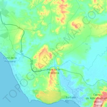
Name: Vejer de la Frontera topographic map, elevation, terrain.
Location: Vejer de la Frontera, La Janda, Cádiz, Andalusia, Spain (36.20590 -6.07971 36.37475 -5.78228)
Average elevation: 174 ft
Minimum elevation: -10 ft
Maximum elevation: 1,037 ft
Make a donation
Gear up for your next adventure:
As an Amazon Associate, this site earns from qualifying purchases at no extra cost to you.
Other topographic maps
Click on a map to view its topography, its elevation and its terrain.
Make a donation
Gear up for your next adventure:
As an Amazon Associate, this site earns from qualifying purchases at no extra cost to you.
Conil de la Frontera
Spain > Andalusia > La Janda > Conil de la Frontera > Conil de la Frontera
Average elevation: 59 ft
Make a donation
Gear up for your next adventure:
As an Amazon Associate, this site earns from qualifying purchases at no extra cost to you.