Geolocate

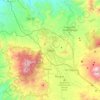
Jala topographic map

Click on the map to display elevation.

About this map
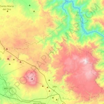
Name: Jala topographic map, elevation, terrain.

Location: Jala, Nayarit, Mexico (21.05392 -104.56237 21.35126 -104.23758)

Average elevation: 4,163 ft

Minimum elevation: 883 ft

Maximum elevation: 8,294 ft

Other topographic maps

Click on a map to view its topography, its elevation and its terrain.

Bucerías

Mexico > Nayarit > Bahía de Banderas

Average elevation: 105 ft

San Rafael

Mexico > Nayarit > Del Nayar

Average elevation: 394 ft

Pericos

Mexico > Nayarit > Rosamorada

Average elevation: 13 ft

Sayulita

Mexico > Nayarit > Bahía de Banderas

Average elevation: 125 ft

Nayarit

Mexico > Nayarit

Average elevation: 3,409 ft

Sayulita

Mexico > Nayarit > Bahía de Banderas

Average elevation: 125 ft

Tepic

Mexico > Nayarit > Tepic

Located in the central part of the state, it stands at an altitude of 915 metres (3,002 ft) above sea level, on the banks of the Río Mololoa and the Río Tepic, approximately 225 kilometres (140 mi) north-west of Guadalajara, Jalisco. Nearby are the volcanoes of San Juan, Las Navajas, and Sangangüey. Tepic…

Average elevation: 3,022 ft

Tepic

Mexico > Nayarit > Tepic

Located in the central part of the state, it stands at an altitude of 915 metres (3,002 ft) above sea level, on the banks of the Río Mololoa and the Río Tepic, approximately 225 kilometres (140 mi) north-west of Guadalajara, Jalisco. Nearby are the extinct Sangangüey volcano and its crater lake. Tepic is…

Average elevation: 3,022 ft
Sayulita

Mexico > Nayarit > Bahía de Banderas

Average elevation: 125 ft

San Blas

Mexico > Nayarit > San Blas

Average elevation: 16 ft

Lo de Marcos

Mexico > Nayarit > Bahía de Banderas

Average elevation: 131 ft

Atotonilco

Mexico > Nayarit > Tecuala

Average elevation: 30 ft

Tepic

Mexico > Nayarit > Tepic

Located in the central part of the state, it stands at an altitude of 915 metres (3,002 ft) above sea level, on the banks of the Río Mololoa and the Río Tepic, approximately 225 kilometres (140 mi) north-west of Guadalajara, Jalisco. Nearby are the volcanoes of San Juan, Las Navajas, and Sangangüey. Tepic…

Average elevation: 3,022 ft
Las Jarretaderas

Mexico > Nayarit > Bahía de Banderas

Average elevation: 13 ft

Cerro Alto

Mexico > Nayarit > Xalisco

Average elevation: 6,060 ft

Guayabitos

Mexico > Nayarit > Tepic > La Libertad

Average elevation: 3,694 ft

El Refilión

Mexico > Nayarit > Compostela

Average elevation: 2,930 ft

El Monteon

Mexico > Nayarit > Compostela

Average elevation: 148 ft

arroyo

Mexico > Nayarit > Bahía de Banderas > Compostela > Ursulo Galvan

Average elevation: 89 ft

Mayorquín

Mexico > Nayarit > Santiago Ixcuintla

Average elevation: 10 ft

Sayulita

Mexico > Nayarit > Bahía de Banderas

Average elevation: 125 ft

Roseta (La Tristeza)

Mexico > Nayarit > Tepic

Average elevation: 518 ft

El Floreño

Mexico > Nayarit > Tepic

Average elevation: 1,033 ft

Gear up for your next adventure:

🧤Tactile Hiking Gloves - Keep hands warm while operating GPS and smartphone screens
🏔️Mountain Trail Maps - High‑detail maps for popular peaks
🛶Inflatable Kayak - Portable kayak for rivers, lakes, and expeditions
🔦Powerful Headlamps - Ultra-bright hands-free lighting for night navigation
📌Outdoor GPS Map App - Apps and devices for digital topographic navigation

As an Amazon Associate, this site earns from qualifying purchases at no extra cost to you.