
Make a donation
Gear up for your next adventure:
As an Amazon Associate, this site earns from qualifying purchases at no extra cost to you.
Brauneck topographic map
Click on the map to display elevation.
Make a donation
Gear up for your next adventure:
As an Amazon Associate, this site earns from qualifying purchases at no extra cost to you.
Brauneck
Das Brauneck in Oberbayern gehört zu den Bayerischen Voralpen (bayerisches Alpenvorland) und ist ein Ausläufer der Benediktenwand. Die Gipfelhöhe beträgt 1555 m ü. NHN, die Talhöhe bei Lenggries 740 m (815 Höhenmeter). Das Brauneckgebiet ist durch Wirtschaftswege und die Brauneck-Bergbahn sowie mehrere Skilifte voll erschlossen und wegen seiner Nähe zur Landeshauptstadt München (60 km) und der Anbindung an die Bayerische Oberlandbahn ein beliebtes Ski- und Wandergebiet. Eine Seilbahn führt auf den Gipfel. Es gibt auf dem Berg mehrere Startplätze für Gleitschirmflieger und Drachenflieger. Am Parkplatz der Brauneck-Bergbahn gibt es einen Landeplatz für Gleitschirmflieger und einen separaten Landeplatz für Drachenflieger.
Make a donation
Gear up for your next adventure:
As an Amazon Associate, this site earns from qualifying purchases at no extra cost to you.
About this map
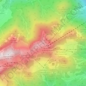
Name: Brauneck topographic map, elevation, terrain.
Average elevation: 4,006 ft
Minimum elevation: 2,579 ft
Maximum elevation: 5,331 ft
Make a donation
Gear up for your next adventure:
As an Amazon Associate, this site earns from qualifying purchases at no extra cost to you.
Other topographic maps
Click on a map to view its topography, its elevation and its terrain.
Sylvensteinspeicher
Deutschland > Bayern > Landkreis Bad Tölz-Wolfratshausen > Lenggries > Fall
Der Stausee wurde nach dem Sylvenstein benannt, einem Felsrücken, der im oberen Isartal eine natürliche Engstelle nach Osten begrenzt. Die westliche Begrenzung ist das felsige Hennenköpfl. Der Sylvensteinsee ist auch ein Ausflugsziel und Erholungsgebiet. Im See versunken liegt das ehemalige Dorf Fall, das…
Average elevation: 3,133 ft