
Make a donation
Gear up for your next adventure:
As an Amazon Associate, this site earns from qualifying purchases at no extra cost to you.
Organyà topographic map
Click on the map to display elevation.
Make a donation
Gear up for your next adventure:
As an Amazon Associate, this site earns from qualifying purchases at no extra cost to you.
About this map
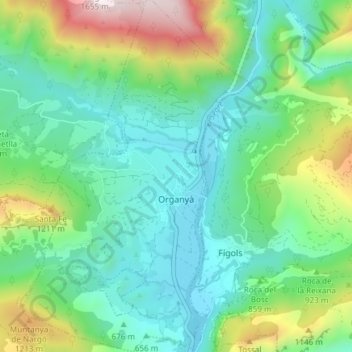
Name: Organyà topographic map, elevation, terrain.
Location: Organyà, Alt Urgell, Lleida, Catalonia, Spain (42.18670 1.29090 42.24209 1.34337)
Average elevation: 2,680 ft
Minimum elevation: 1,693 ft
Maximum elevation: 5,328 ft
Make a donation
Gear up for your next adventure:
As an Amazon Associate, this site earns from qualifying purchases at no extra cost to you.
Other topographic maps
Click on a map to view its topography, its elevation and its terrain.
Bony de Serena
Spain > Catalonia > Alt Urgell > les Valls de Valira > Bordes de Jussà
Average elevation: 5,889 ft
Make a donation
Gear up for your next adventure:
As an Amazon Associate, this site earns from qualifying purchases at no extra cost to you.