
Make a donation
Gear up for your next adventure:
As an Amazon Associate, this site earns from qualifying purchases at no extra cost to you.
Blerick topographic map
Click on the map to display elevation.
Make a donation
Gear up for your next adventure:
As an Amazon Associate, this site earns from qualifying purchases at no extra cost to you.
Blerick
Blerick ligt op de westoever van de Maas, op een hoogte van ongeveer 18 meter. Door een spoorbrug en een verkeersbrug is Blerick met Venlo verbonden. Ten noorden van Blerick vindt men een industriehaven en grootschalige bedrijventerreinen, waartussen de buurtschap Ubroek ligt geklemd. In het westen ligt Boekend en de Blerickse Bergen, een naaldbosgebied op oude rivierduinen. In het zuiden is Blerick vastgebouwd aan Hout-Blerick.
Make a donation
Gear up for your next adventure:
As an Amazon Associate, this site earns from qualifying purchases at no extra cost to you.
About this map
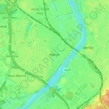
Name: Blerick topographic map, elevation, terrain.
Location: Blerick, Venlo, Limburg, Nederland, 5921 XW, Nederland (51.34765 6.12916 51.38765 6.16916)
Average elevation: 75 ft
Minimum elevation: 30 ft
Maximum elevation: 138 ft
Make a donation
Gear up for your next adventure:
As an Amazon Associate, this site earns from qualifying purchases at no extra cost to you.