Geolocate

Orleans Square topographic map

Click on the map to display elevation.

About this map

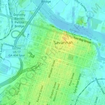
Name: Orleans Square topographic map, elevation, terrain.

Location: Orleans Square, Savannah Historic District, Savannah, Chatham County, Georgia, United States (32.07604 -81.09578 32.07670 -81.09499)

Average elevation: 30 ft

Minimum elevation: -3 ft

Maximum elevation: 85 ft

Chatham County trails, hiking, mountain biking, running and outdoor activities

Other topographic maps

Click on a map to view its topography, its elevation and its terrain.

Mount Herman

United States > Georgia > Chatham County > Savannah

Average elevation: 20 ft

Welwood

United States > Georgia > Chatham County > Savannah > Welwood

Average elevation: 23 ft

Lynhurst

United States > Georgia > Chatham County > Savannah

Average elevation: 26 ft

Colonial Oaks

United States > Georgia > Chatham County > Savannah

Average elevation: 23 ft

Fig Island

United States > Georgia > Chatham County > Savannah

Average elevation: 16 ft

Oakdale

United States > Georgia > Chatham County > Savannah

Average elevation: 33 ft

Gear up for your next adventure:

🔭Telescopic Hiking Pole - Adjustable pole for hiking stability
GPS Sports Watch - GPS watch for running, hiking and training
🧦Merino Wool Socks - Moisture-wicking, blister-preventing socks for long treks
🔥Plasma Lighters - Windproof lighters that work in any weather condition
🛰️Satellite Messengers - Emergency SOS and two-way messaging for off-grid adventures

As an Amazon Associate, this site earns from qualifying purchases at no extra cost to you.