
Make a donation
Gear up for your next adventure:
As an Amazon Associate, this site earns from qualifying purchases at no extra cost to you.
Quiche topographic map
Click on the map to display elevation.
Make a donation
Gear up for your next adventure:
As an Amazon Associate, this site earns from qualifying purchases at no extra cost to you.
About this map
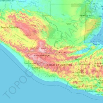
Name: Quiche topographic map, elevation, terrain.
Location: Quiche, Guatemala (12.81956 -93.54605 18.01956 -88.34605)
Average elevation: 1,568 ft
Minimum elevation: -10 ft
Maximum elevation: 13,553 ft
Make a donation
Gear up for your next adventure:
As an Amazon Associate, this site earns from qualifying purchases at no extra cost to you.
Other topographic maps
Click on a map to view its topography, its elevation and its terrain.
Make a donation
Gear up for your next adventure:
As an Amazon Associate, this site earns from qualifying purchases at no extra cost to you.
San Marcos
The climate varies widely within the department, due to the dramatic differences in altitude, with the north possessing a cold Guatemalan Highlands climate and the south having a temperate or hot climate, depending on the specific altitude.
Average elevation: 4,413 ft
Make a donation
Gear up for your next adventure:
As an Amazon Associate, this site earns from qualifying purchases at no extra cost to you.