Geolocate

Pendleton topographic map

Click on the map to display elevation.

About this map

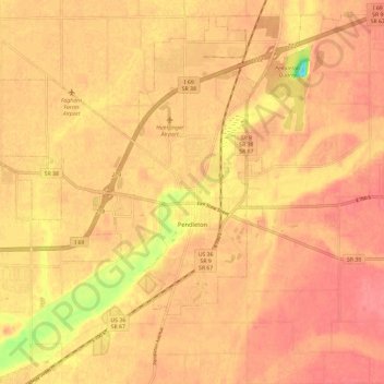
Name: Pendleton topographic map, elevation, terrain.

Location: Pendleton, Madison County, Indiana, United States (39.97625 -85.84306 40.03402 -85.72502)

Average elevation: 879 ft

Minimum elevation: 719 ft

Maximum elevation: 932 ft

Madison County trails, hiking, mountain biking, running and outdoor activities

Other topographic maps

Click on a map to view its topography, its elevation and its terrain.

Western Village

United States > Indiana > Madison County > Anderson

Average elevation: 873 ft

North Anderson

United States > Indiana > Madison County > Anderson

Average elevation: 879 ft

Hillcrest

United States > Indiana > Madison County > Anderson

Average elevation: 883 ft

Gear up for your next adventure:

🥘Titanium Cookware - Durable, featherlight pots and pans for backpacking
🧤Hiking Gloves - Protective gloves for rugged trails
🛡️Insect Repellent - Protection against bugs during outdoor activities
🔦LED Headlamp - Bright and durable LED headlamp for night navigation
🪶Camp Gear Gift Set - Perfect gift bundle for outdoor fans

As an Amazon Associate, this site earns from qualifying purchases at no extra cost to you.