Geolocate

Factoryville topographic map

Click on the map to display elevation.

About this map

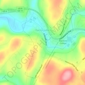
Name: Factoryville topographic map, elevation, terrain.

Location: Factoryville, Wyoming County, Pennsylvania, United States (41.54777 -75.79086 41.57059 -75.77191)

Average elevation: 984 ft

Minimum elevation: 791 ft

Maximum elevation: 1,227 ft

Wyoming County trails, hiking, mountain biking, running and outdoor activities

Other topographic maps

Click on a map to view its topography, its elevation and its terrain.

Noxen

United States > Pennsylvania > Wyoming County

Average elevation: 1,322 ft

Lake Winola

United States > Pennsylvania > Wyoming County

Average elevation: 1,086 ft

Evans Falls

United States > Pennsylvania > Wyoming County

Average elevation: 1,240 ft

Mehoopany

United States > Pennsylvania > Wyoming County

Average elevation: 922 ft

Gear up for your next adventure:

🪶Paracord Bracelet - Survival bracelet with built‑in tools
🧭Orienteering Set - Complete compass and map reading kit
🧦Merino Wool Socks - Moisture-wicking, blister-preventing socks for long treks
🧭GPS Watch Accessories - Bands and chargers for GPS watches
🧥Men's Rain Shells - Premium waterproof and breathable jackets for mountain weather

As an Amazon Associate, this site earns from qualifying purchases at no extra cost to you.