
Make a donation
Gear up for your next adventure:
As an Amazon Associate, this site earns from qualifying purchases at no extra cost to you.
Trece Martires topographic map
Click on the map to display elevation.
Make a donation
Gear up for your next adventure:
As an Amazon Associate, this site earns from qualifying purchases at no extra cost to you.
Trece Martires
The city of Trece Martires is characterised with ground elevation ranging from 30 metres (98 ft) to nearly 400 metres (1,300 ft). Its ground slope ranges from 0.5 to 2%.
Make a donation
Gear up for your next adventure:
As an Amazon Associate, this site earns from qualifying purchases at no extra cost to you.
About this map
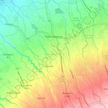
Name: Trece Martires topographic map, elevation, terrain.
Location: Trece Martires, Cavite, Calabarzon, 4109, Philippines (14.21817 120.82293 14.31353 120.90154)
Average elevation: 466 ft
Minimum elevation: 118 ft
Maximum elevation: 938 ft
Make a donation
Gear up for your next adventure:
As an Amazon Associate, this site earns from qualifying purchases at no extra cost to you.
Other topographic maps
Click on a map to view its topography, its elevation and its terrain.