
Make a donation
Gear up for your next adventure:
As an Amazon Associate, this site earns from qualifying purchases at no extra cost to you.
Jauja topographic map
Click on the map to display elevation.
Make a donation
Gear up for your next adventure:
As an Amazon Associate, this site earns from qualifying purchases at no extra cost to you.
About this map
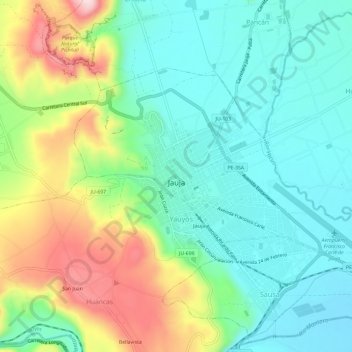
Name: Jauja topographic map, elevation, terrain.
Location: Jauja, Junín, Peru (-11.79214 -75.51723 -11.75637 -75.45798)
Average elevation: 11,289 ft
Minimum elevation: 10,965 ft
Maximum elevation: 11,985 ft
Make a donation
Gear up for your next adventure:
As an Amazon Associate, this site earns from qualifying purchases at no extra cost to you.
Other topographic maps
Click on a map to view its topography, its elevation and its terrain.
La Merced
Peru > Junín > Chanchamayo
Die Stadt liegt in der peruanischen Zentralkordillere auf einer Höhe von 751 m. Sie liegt 75 Kilometer Luftlinie östlich der Stadt Junín sowie 220 Kilometer nordöstlich der Landeshauptstadt Lima. Auf der asphaltierten Straße sind es 305 km von Lima bis La Merced. Sie liegt am Westufer des Río…
Average elevation: 3,537 ft