
Thank you for supporting this site ❤️
Make a donation
Make a donation
Gear up for your next adventure:
As an Amazon Associate, this site earns from qualifying purchases at no extra cost to you.
Letenye topographic map
Click on the map to display elevation.
Thank you for supporting this site ❤️
Make a donation
Make a donation
Gear up for your next adventure:
As an Amazon Associate, this site earns from qualifying purchases at no extra cost to you.
About this map
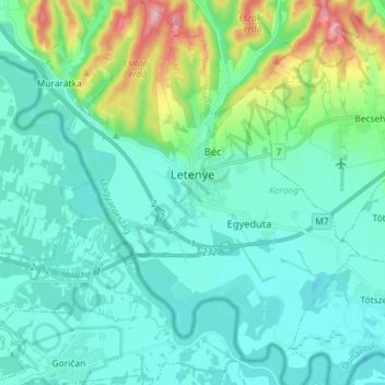
Name: Letenye topographic map, elevation, terrain.
Location: Letenye, Letenyei járás, Zala, Transdanubia, 8868, Hungary (46.37764 16.67439 46.47784 16.78574)
Average elevation: 541 ft
Minimum elevation: 427 ft
Maximum elevation: 1,047 ft
Thank you for supporting this site ❤️
Make a donation
Make a donation
Gear up for your next adventure:
As an Amazon Associate, this site earns from qualifying purchases at no extra cost to you.