
Make a donation
Gear up for your next adventure:
As an Amazon Associate, this site earns from qualifying purchases at no extra cost to you.
Fuente Vaqueros topographic map
Click on the map to display elevation.
Make a donation
Gear up for your next adventure:
As an Amazon Associate, this site earns from qualifying purchases at no extra cost to you.
About this map
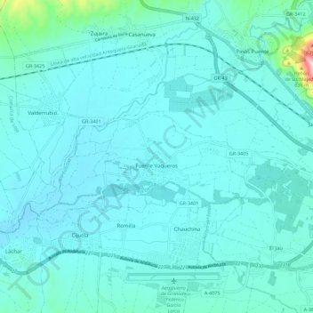
Name: Fuente Vaqueros topographic map, elevation, terrain.
Average elevation: 1,860 ft
Minimum elevation: 1,716 ft
Maximum elevation: 3,189 ft
Make a donation
Gear up for your next adventure:
As an Amazon Associate, this site earns from qualifying purchases at no extra cost to you.
Other topographic maps
Click on a map to view its topography, its elevation and its terrain.
Jardines del Triunfo
Spain > Andalusia > Comarca de la Vega de Granada > Granada
Average elevation: 2,359 ft
Cortijo del Aire
Spain > Andalusia > Comarca de la Vega de Granada > Albolote
Average elevation: 2,316 ft
Make a donation
Gear up for your next adventure:
As an Amazon Associate, this site earns from qualifying purchases at no extra cost to you.