
Make a donation
Gear up for your next adventure:
As an Amazon Associate, this site earns from qualifying purchases at no extra cost to you.
Yerupajá topographic map
Click on the map to display elevation.
Make a donation
Gear up for your next adventure:
As an Amazon Associate, this site earns from qualifying purchases at no extra cost to you.
Yerupajá
Based on the elevation provided by the available Digital elevation models, SRTM2 (6558m with voids), SRTM filled with ASTER (6551m with voids), TanDEM-X(6110m with voids), Yerupaja is about 6635 meters above sea level. This altitude was considered due to the lack of topographic data or even handheld GPS data.
Make a donation
Gear up for your next adventure:
As an Amazon Associate, this site earns from qualifying purchases at no extra cost to you.
About this map
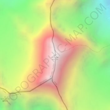
Name: Yerupajá topographic map, elevation, terrain.
Location: Yerupajá, Pacllón, Province of Bolognesi, Ancash, Peru (-10.26867 -76.90561 -10.26857 -76.90551)
Average elevation: 18,494 ft
Minimum elevation: 15,413 ft
Maximum elevation: 21,345 ft
Make a donation
Gear up for your next adventure:
As an Amazon Associate, this site earns from qualifying purchases at no extra cost to you.