Geolocate
👉 Easily get elevation data in JSON, GeoTIFF and KML formats using Elevation API
Thank you for supporting this site ❤️
Make a donation

Tanner topographic map

Click on the map to display elevation.

About this map

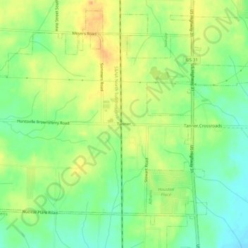
Name: Tanner topographic map, elevation, terrain.

Location: Tanner, Limestone County, Alabama, 35671, United States (34.71148 -86.99056 34.75148 -86.95056)

Average elevation: 653 ft

Minimum elevation: 591 ft

Maximum elevation: 715 ft

Limestone County trails, hiking, mountain biking, running and outdoor activities

Other topographic maps

Click on a map to view its topography, its elevation and its terrain.

Elkmont

United States > Alabama > Limestone County

Average elevation: 817 ft

Athens

United States > Alabama > Limestone County

Average elevation: 669 ft

Elkmont

United States > Alabama > Limestone County

Average elevation: 817 ft

Athens

United States > Alabama > Limestone County

Average elevation: 669 ft

Gear up for your next adventure:

🪶LED Camping Lantern - Bright lantern for camp lighting
🥤Water Filter Bottle - All‑in‑one filter bottle for safe hydration
🎒Gear Packing Cubes - Organize your backpack efficiently
🔭Compact Binoculars - HD vision for scouting terrain and identifying distant landmarks
🧭Compass with Lanyard - Easy‑carry compass for navigation

As an Amazon Associate, this site earns from qualifying purchases at no extra cost to you.