Geolocate

Panamaram topographic map

Click on the map to display elevation.

About this map

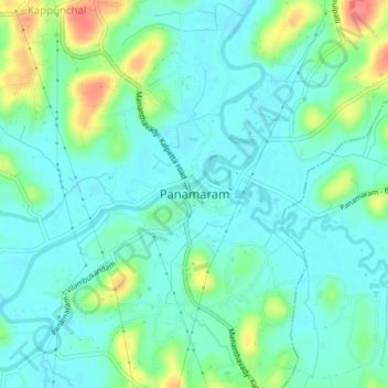
Name: Panamaram topographic map, elevation, terrain.

Location: Panamaram, Mananthavady, Wayanad, Kerala, 670721, India (11.70039 76.03377 11.78039 76.11377)

Average elevation: 2,415 ft

Minimum elevation: 2,339 ft

Maximum elevation: 2,710 ft

Gear up for your next adventure:

🪑Portable Camp Table - Compact table for campsite meals
🩹Survival Bandages - High‑quality bandages for emergencies
🔌USB Car Charger - Car charger for on‑the‑go power needs
🥘Titanium Cookware - Durable, featherlight pots and pans for backpacking
🪶Fire Starter Kit - Reliable fire starter for survival and camping

As an Amazon Associate, this site earns from qualifying purchases at no extra cost to you.